It takes time and a bit of search to figure out and find the few hiking trails above the cliffs of Olhos de Agua in the Albufeira district.
Hopefully, this site will help hikers to enjoy getting on the trails in the area. Facing South, that is towards the Ocean, there are two directions to go hiking: you can choose either to go East or to go West. So this is how the proposed itineraries are organized.
 |
| Cliff panorama on Falésia |
A- WESTWARDS:
This is a picturesque hike providing an excellent scope of the rock formation as well as the natural habitat on the cliffs.
It is slightly challenging as some parts of the trail are covered up by vegetation and also because some areas are steep and dangerously following the edge of the cliffs. But there is a wood fence all along, although in some parts it has been damaged by erosion and weather conditions. There are warning signs telling to AVOID BEING TOO CLOSE TO THE CLIFF EDGE DUE TO ACCIDENTAL LANDSLIDE. But with sound protective measures, this is a superb hiking trail. There are benches at places that allow hikers either to rest or to sit to enjoy the view and the ocean breeze.
1.HOW to find the trail: A good landmark to start is the local Post Office (CTT de Olhos de Agua), which is on Rua Torre da Medronheira. You simply stay on this road going West.
Once you reach, on your left, a complex called Villa d’Agua, there is a road going downhill (Aldeamento Villa d’Agua). It’s a dead end with a parking area. There is a Portuguese villa to your left and just next to it, you will find a fence door. THIS IS the entrance to the TRAIL.
Enter the upper part of the trail with a picnic area under the trees on your right. You will soon see the ocean from above the cliffs.
2.WHERE does it go to: At this stage, there is a small fork. The trail along the cliffs runs on the right side. But first, you may want to go on the left to walk to a viewpoint on Olhos de Agua.
 |
| Trail view on Olhos de Agua |
You will have to walk back as this is a dead end.
The most interesting lies on the other side. It goes as far as a sandy beach called Praia Maria Luisa.
3.WHAT to see: There are many viewpoints and a few benches to rest along the
 |
| Trail view |
way. The geology is particularly interesting. The rocks are made of a red and white limestone, which has been dramatically eroded by the rainfalls and the sea below. There are many hollows and caves at sea-level. But right at the start of the trail, there is a formation in progress of fairy chimneys. As you keep walking the waves resonate under the empty hollows beneath.There are a few rock holes, natural trenches, tiny coves and also a natural arch on the water’s side of a rock circus.
The vegetation on top of the cliff is quite interesting too. Just before you get to the beach of Praia Maria Luisa, the wood staircase leads to the front gardens of villas having an outstanding sea-view.
 |
| Tiny cove |
Then, you reach another fork. If you want to go down to the beach, turn right. The other side, on the right, has stairs leading back to the same street you came (Rua Torre da Medronheira).
You could decide to start the trail from that side as well instead of the one previously described.
4.WHEN to be there: You can choose to visit the trail any time during the day. But, on a fine day the colors are particularly beautiful at sunset times.
 |
| A formation of fairy chimneys |
 |
| Natural arch |
 |
| Cliff hole |
 |
| Praia Maria Luisa |
B-EASTWARDS:
On this other side of town, there are no less than three different hiking trails to go on! And they are all very different!
1.HOW to take the direction to all three trails: The best starting landmark is the round-about at the eastern end of Olhos de Agua, just past the Medical Centre (Centro Medico). Turn right on to Rua 25 de Abril, which goes down to the beach The first road on your left goes uphill to Hotel Riu Guarana. Then turn right into the road, which runs along Hotel Riu, going southwards. This road is a dead end, but just at the bend, you will see a sort of colorful monument made with a fishing boat. Past this landmark, on your left side, you will first see the upper part of a staircase going downhill and if tou look closely, there is also a nature trail just lying next to the stairs.
The two hiking trails there are right there! Let’s start with the small lane on the right.
2.TRAIL 1: Eastern viewpoint over Olhos de Agua beach. This is a non-secure nature  |
| Lighthouse view |
hike. If you fear heights, stop once you reach the cliff ridge. Otherwise, it goes as far as a small lighthouse above the eastern side of Praia dos Olhos de Agua. There are some dramatic sights over the cliff formation and the viewpoint over the beach and the lower part of Olhos de Agua is awesome.
You must go back to this starting point to get to the next trail.
 |
| Viewpoint on Falésia |
—> But before going downhill on the next trail, we suggest you to walk just in the area lying behind the colorful boat. It is a flat area on top of the cliff range that provides a few viewpoints. It is called Miradouro da Falésia. Really worth to see as you get a unique view over Falésia.
 |
| Another dramatic viewpoint from 'Miradouro da Falésia' |
3.TRAIL 2: This is an easy way to go downhill through a long series of stairs. As you proceed going down, at one point, you will have to choose to either go right or go |
| Way down to the cove |
left.
-If you go right, you reach a sandy cove,
-If you go left, your purse the hike to the western end of Falésia beach.
It sounds like an easy way to hike, except that you need to keep in mind that you must climb back hundreds of stairs!
BUT, if you choose the right time of day, when it is LOW TIDE, then you can easily walk back to Praia dos Olhos de Agua over the rocks.
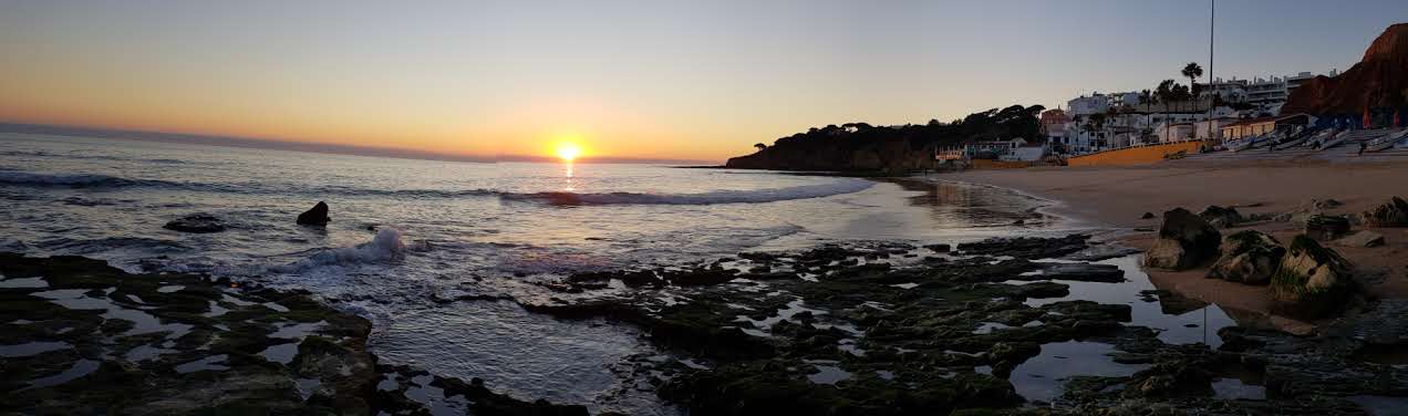
 |
| Sunset over Olhos de Agua Beach |
4.TRAIL 3: The shortest hike from Olhos de Agua to Paris de Falésia is there. Let’s call it the FALESIA TRAIL.
-If you go from the boat monument, on the way back to Hotel Riu, on the right there |
| Stairs to Falésia Beach |
is a road leading to Hotel Falésia. Past the hotel driveway you walk to the end and you will find a lane on your right,
-If you come from Olhos de Agua, and that you want to go straight to this trail, once you have the Hotel Riu Guarana on your right, you simply continue straight and you will get to a corner going to Hotel Falésia. You will also see the lane on to the right.
This lane is a passage between two properties. At the end, you only have the alternative to turn left and then you will reach the stairs that take you downhill. You will come into a dust road leading to Falésia Beach on to the right.
Once you get to Praia da Falésia you have miles and miles to walk - unless you want to jog - in a spectacular natural site mentioned by Unesco.
 |
| Cliff view on Praia da Falésia |
 |
| On Praia da Falésia |